| Can be used with many commercial echo-sounders, pingers, and boomers |
| Signal and trigg-pulse connects to an A/D-card in the computer |
| Full-wave digitizing of the return signal |
| Digital signal enhancement for analysis and reports |
| Simultaneously works as a digital echo-sounder |
| Records digital depth together with GPS position |
| Resolution, max frequency and max range depend on choice of A/D-converter |
General
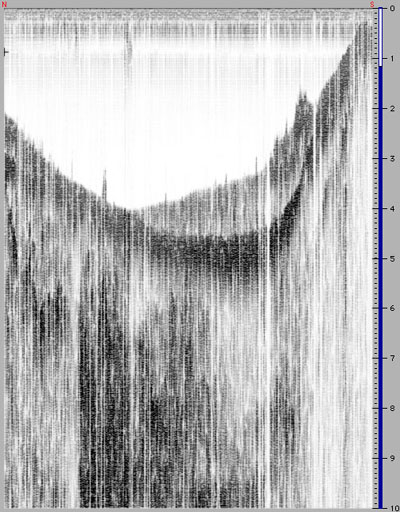
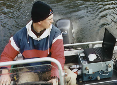
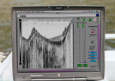
There are many sonar systems on the market, but few if any that address our requirements for soft sediment mapping, in the fields of environmental investigations, and geomorphologic mapping for environmental hazard studies.It was decided to make a virtual instrument (i.e., a computer software), that can be used with a wide range of hardware, and at different frequencies. The pictures here depict the tests with an Atlas Monograph 30 kHz echosounder. The SediPing software takes over for depth measurements and plotting, and also adds a sub-bottom TVG. The results are stunning.
Components
The SediPing is a "Virtual Instrument" software developed in LabVIEW (from National Instruments). It can be run on any platform that LabVIEW supports, including Windows, Unix, and Macintosh. Apart from the SediPing software and the digitizer, some sonar hardware is required.The sonar can be any echo-sounder, sub-bottom profiler or seismic energy source, from which the signal and trig pulse can be taken out. This is possible from all systems consisting of separate units for transmitting and receiving, such as the GeoPulse pinger system, or where an external printer is used. This type of simple, industry-standard equipment can be rented in many countries.
Flexible and adjustable
The SediPing can print the data on screen, and store it in a file for later analysis. It also detects the depth and may record depth data together with position data in a text file.Using a software solution rather than hardware, makes it possible to make a very flexible system. There are many useful features as is, but most importantly, the specifications can be changed quickly with the help of the graphical programming language, making it possible to respond to new and un-foreseen demands during a field mission.
Many settings are adjustable from the front panel. Less often used controls are available by scrolling the window to the right. In the event that an algorithm needs to be changed (for instance as the result of using the software for another purpose), it is easily and quickly made using the graphical programming environment of LabVIEW.
The possibility to use different hardware, and to adjust the software at will, makes it completely open and guarantees the long-term value of the investment.